Published ~ 20 January 2024

Underground Locator

Firstly, what is an Underground Locator?

An underground service locator is a certified and specialised Utility Contractor, equipped with advanced equipment and industry expertise to detect and identify underground pipes and cables accurately.


They are also referred to as:


  • Underground Locator
  • Pipe Locator
  • Cable Locators
  • Line Locator
  • Underground Cable Locator
  • Ground Penetrating Radar (GPR) Technician
  • Telstra Locator
  • Underground Locating Services
  • Underground Service Detection
  • Underground Service Mapping


Understanding Our Techniques:


The primary techniques employed by underground service locators include Electromagnetic Pipe Locator and Ground Penetrating Radar (GPR).


Electromagnetic Pipe Locator: This method utilises a two-piece set of equipment comprising a transmitter and a receiver. The transmitter emits an electromagnetic signal into conductive materials such as steel or copper pipes. By tuning the receiver to the specific frequency transmitted by the transmitter, professionals can detect and pinpoint the location of underground services. Different frequencies allow for the isolation of individual services amidst multiple underground utilities, enhancing accuracy and efficiency.


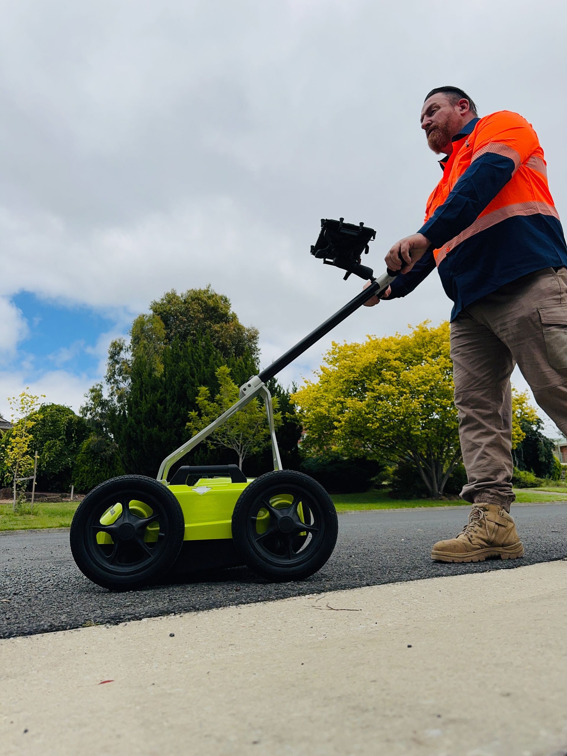
Ground Penetrating Radar (GPR): GPR technology involves the use of an antenna, typically mounted on a wheeled cart, to pulse radar waves into the ground. These waves penetrate the subsurface and bounce back upon encountering underground structures such as pipes, rocks, or tree roots. GPR enables professionals to visualise underground structures and detect non-conductive materials like plastic pipes.


When to engage Underground Locating Services?


The need for hiring an underground service locator arises whenever excavation or construction activities are planned in areas where underground services are present. This responsibility applies not only to private property owners but also to businesses, organisations, and public service providers reliant on underground infrastructure.


Private Areas: Property owners must ensure the protection of underground services within their premises. While damaging private services may not pose significant risks, it's essential to ascertain that critical services like underground power or gas lines are not affected, as they can lead to severe injuries or fatalities if damaged.


Public Areas: In public settings or areas where multiple stakeholders rely on underground services, the responsibility of protecting these services becomes even more critical. Any interruption or damage to public services can result in legal liabilities and financial losses for the responsible parties.


Underground Locator Services Costs:


The cost of hiring an underground service locator vary across the industry. However, the investment cost for Pulse Locating Services begins at $260 for the first hour, followed by $140 per hour for every other hour up to 8 hrs. Additional cost are typically incurred beyond 8 hrs and depending on the location of the task. Additional factors influencing the cost include the complexity of the job, the location of underground services, and the level of preparation required.


Things you can do that might help you save money.


Property owners can take several preparation measures to expedite the locating process and potentially reduce costs:


In consultation with Pulse Locating Services, you may consider submitting a Dial Before You Dig request prior to your Utility Locator undertaking the task. Doing so will provide an opportunity for asset owners to action any tasks necessary and forward appropriate information.


Depending on the location that requires surveying, removing any debris or obstructions from areas where service locators need to access underground utilities will help greatly. When you underground locator is on site, you want them to be actioning their skills. The last thing you want them to be doing moving rubbish so they can access places.


Obtaining underground service plans from contractors, facility maintenance personnel, or property managers can provide valuable insights into the location and layout of underground infrastructure.


Conclusion:


Engaging the services of an underground service locator is essential for any construction or excavation project involving underground services and, in some cases, mandatory. By understanding the techniques, responsibilities, and cost factors associated with hiring a locator, property owners and project managers can ensure the safe and efficient execution of their projects while minimising risks and liabilities.

Image depicts an unmarked grave with up to 10 unmarked headstones.
By Pulse Locating Services February 4, 2024
Outlining the benefits of Ground Penetrating Radar (GPR) and how it maybe utilised in the works around locating unmarked graves. Moreover, it discusses the limitations of GPR for grave detection but also how to harness modern technology for such purposes.
Image depicts a utility locator pushing GPR.
By Pulse Locating Services December 1, 2023
Deciphering Utility Mapping: Navigating Beneath the Surface Utility mapping, a cornerstone of modern infrastructure management and urban planning, is a methodical process aimed at accurately charting and cataloguing underground utilities and infrastructure. As our cities grow and evolve, the need to understand what lies beneath the surface becomes increasingly critical. In this article, we'll delve into the intricacies of utility mapping, its significance, and the technologies driving its evolution. Understanding Utility Mapping Utility mapping involves the systematic identification, location, and documentation of underground utilities such as water pipes, sewer lines, gas mains, electrical cables, and telecommunication networks. By creating detailed maps and records of these essential assets, utility mapping facilitates informed decision-making, reduces the risk of damage during construction and excavation, and enhances the overall efficiency of infrastructure management. The Significance of Utility Mapping The importance of utility mapping cannot be overstated, particularly in densely populated urban areas where underground utilities crisscross beneath streets, sidewalks, and buildings. Accurate mapping helps utility companies, city planners, engineers, and construction firms avoid costly and potentially dangerous conflicts with buried infrastructure. Additionally, utility mapping plays a vital role in emergency response efforts, allowing first responders to quickly locate and access critical utilities during emergencies such as gas leaks or water main breaks. Technologies Driving Utility Mapping Advancements in technology have revolutionised the field of utility mapping, enabling more efficient and precise data collection, analysis, and visualisation. Some of the key technologies driving utility mapping include: Ground Penetrating Radar (GPR): GPR uses radar pulses to penetrate the ground and detect subsurface features, including buried utilities. This non-destructive method provides high-resolution images of underground infrastructure, making it an invaluable tool for utility mapping projects. Electromagnetic Locators: Electromagnetic locators detect the electromagnetic fields generated by buried utilities, allowing operators to trace their paths and accurately map their locations. Geographic Information Systems (GIS): GIS software enables the storage, analysis, and visualisation of spatial data, including utility maps. By integrating utility mapping data with other geographic information, GIS helps stakeholders make informed decisions about infrastructure planning and management. Benefits of Utility Mapping The benefits of utility mapping are far-reaching and multifaceted: Risk Mitigation: By accurately mapping underground utilities, utility mapping helps identify potential conflicts and hazards before construction or excavation begins, reducing the risk of accidents, injuries, and costly delays. Cost Savings: Avoiding damage to buried utilities saves money on repairs, downtime, and legal liabilities. Additionally, efficient infrastructure planning and maintenance based on accurate mapping data can optimise resource allocation and minimise operational costs. Enhanced Resilience: In an increasingly interconnected world, resilient infrastructure is essential for maintaining essential services and ensuring public safety. Utility mapping contributes to resilience by providing the information needed to plan for and respond to emergencies effectively. Utility mapping is a fundamental component of modern infrastructure management and urban planning. By accurately charting underground utilities and infrastructure, utility mapping improves safety, efficiency, and resilience while reducing costs and mitigating risks. As technology continues to advance, utility mapping will play an increasingly vital role in shaping the cities of tomorrow and ensuring they remain safe, sustainable, and liveable for generations to come.
Image depicts Warren Eeles using an underground locating device to locate pipes.
By Pulse Locating Services November 1, 2023
This article discusses the importance of locating pipes before any works is conducted. Dial before you dig. It also discussed the types of pipes likely to be located, the types of equipment Pulse Locating Services uses and the benefits of using them.